


UAV Drone Aerial Surveying Services
What Are UAV Drone Surveys?
UAV (Unmanned Aerial Vehicle) surveying uses drones to collect accurate, high-resolution spatial data from above fast, safely, and without disrupting your site.
Overview of Drone-Based Surveying
Instead of walking the site with traditional tools, we fly over it , capturing aerial imagery and geospatial data for analysis, mapping, modelling and more.
It’s ideal for:
✔ Large or hard-to-access areas
✔ Projects on tight timelines
✔ High risk sites with extensive safety requirements
Benefits Over Traditional Methods
► Speed: Cover more ground in less time
► Safety: No personnel in dangerous or restricted zones
► Accuracy: Centimetre-level data backed by RTK GPS
► Clarity: Visual outputs your whole team can understand

Technology Behind Our UAV Surveys
We combine CASA-certified pilots with cutting-edge photogrammetry and GPS tech to deliver seriously accurate outputs, fast.
High-Resolution Imaging & Mapping
We capture:
► Orthomosaic imagery
► Georeferenced maps
► DEMs (digital elevation models)
► High-res site progress images
All of it fully measurable and ready to use in your workflows.
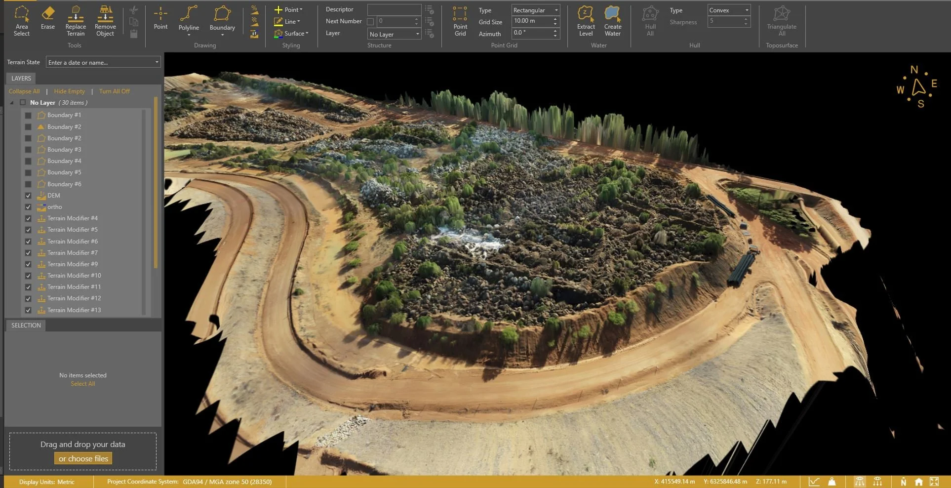
Photogrammetry and 3D Modeling
Using aerial photos stitched together with millimetre accuracy, we produce:
► 3D terrain and surface models
► Interactive visualisations
► Outputs compatible with your CAD or BIM software
Why Choose Drone Surveys?
UAV data is a smarter, faster way to manage your site, especially if you’re working with tight deadlines or complex terrain.
Improved Speed, Safety, and Coverage
Zero site shutdowns
Less time on-site
Full coverage, including tricky or dangerous areas

Accurate Data for Informed Decisions
We provide spatially accurate, up-to-date data that helps you:
Avoid costly errors
Track progress
Improve planning and communication
Make confident, data-backed decisions
Applications of Aerial Surveying
Our drone surveys deliver real outcomes for your site, team and timeline.
Land Development & Planning
Need to make decisions before anyone’s turned a shovel?
We provide:
Pre-construction terrain mapping
Site context for DA and design
Elevation models and boundary overlays
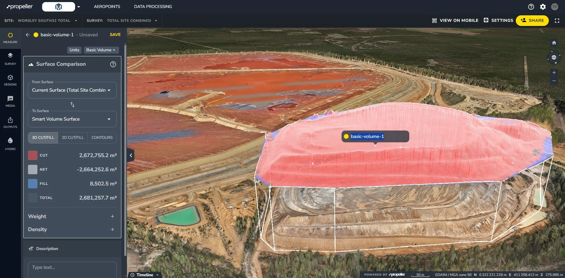
Construction Progress & Volume Analysis
Drones aren’t just for planning, they’re perfect for active construction sites too.
Stockpile volumes
Cut/fill calculations
Progress photos and videos
QA documentation and reporting
Our Drone Surveying Process
We’ve got the tech, the approvals and the process to get your drone data done, quickly, safely and professionally.
Flight Planning & Regulatory Compliance
We handle it all:
CASA-certified pilots
Pre-flight checks and planning
Risk assessments and safety protocols
Flight logs and approvals
Data Capture, Processing & Delivery
After flying the site, we:
Process your data in secure software
Generate the required outputs (maps, models, volumes etc.)
Deliver it all in a format that actually works for your team

Want the Full Picture from the Sky?
Contact us now or request a tailored quote.